Adullam Orphanage
Ghana
Malawi
Mozambique
Nigeria
Tanzania
Uganda
|
|
home >> africa
appeal >>ghana>>ghana geography
Ghana
-geography
Information sourced from wikipedia.org
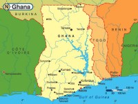 |
Ghana is a country located on the
Gulf of Guinea, only a few degrees north of the Equator, therefore
giving it a warm climate. The Greenwich Meridian also passes
through Ghana, specifically through the industrial city of Ghana-Tema;
so it is said that Ghana is geographically closer to the "center"
of the world than any other country. Côte d'Ivoire is
located to the west of Ghana while Burkina Faso and Togo are
located to its north and east respectively. |
The coastline is mostly a low, sandy shore backed by plains and scrub
and intersected by several rivers and streams. A tropical rain forest
belt, broken by heavily forested hills and many streams and rivers,
extends northward from the shore. North of this belt, the land is
covered by low bush, park-like savannah, and grassy plains.
 The
climate is tropical. The eastern coastal belt is warm and comparatively
dry (see Dahomey Gap); the southwest corner, hot and humid; and
the north, hot and dry. Lake Volta, the world's largest artificial
lake, extends through large portions of eastern Ghana. The
climate is tropical. The eastern coastal belt is warm and comparatively
dry (see Dahomey Gap); the southwest corner, hot and humid; and
the north, hot and dry. Lake Volta, the world's largest artificial
lake, extends through large portions of eastern Ghana.
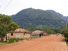
Ghana's highest point, seen here is Mount Afadjato,
seen here from the village of Liati Wote
|
|